


Cappadocia Region; The Land of Fairy Chimneys
Cappadocia is the name of a region in Central Anatolia, incorporating Nevsehir, Aksaray, Nigde, and Kırsehir provinces. Specifically, Uchisar, Goreme, Avanos, Urgup, Derinkuyu, and Ihlara cities are the popular destinations where fairy chimney land formations exist. This area has been mysterious cities which has been home for early Christians. Over the centuries, people caved these unique rock formations and built churches, houses and over 250 underground cities.

The Cappadocia region is one of the most important tourism destinations in Turkey and even in the entire world (Türk, 2020: 26). Having been included in the UNESCO World Heritage list in 1985, the region was accepted as the common heritage of humanity and was declared as a protected area (Ersun and Arslan, 2002: 144; Yıldız and Kılıç, 2016 cited in Türk, 2020, pp. 26-27).Its historical treasures, unique geographical structures and cultural potential have turned it into a popular destination for thousands of local and foreign tourists every year. In world tourism, as a result of tourists’ inclination to explore places beyond the typical sun, sea, and beach triangle, new tourist destinations have gained popularity. (Şamiloğlu and Serin, 2011). In this context, interest in the region and the popularity of the region is improving each year and particularly global awareness and visibility of the region is increasing substantially. However, it has not yet been known sufficiently in World tourism as it deserves.
Today, Cappadocia is like an open air museum welcoming millions of visitors each year. It’s hot air balloon ride is a “must do” for most travelers. You can also enjoy watching hundreds of balloons from terraces in the early morning.
Cappadocia offers a unique heritage of humanity and heritage for visitors! You are welcome to experience different cultures and amazing activities in Cappadocia with our Turkey small group or private tours!
There is no place on earth where there are such rich touristic structures like that of the Cappadocia region. In this region, the trio of history, culture and nature harmonically fascinates its visitors (Şamiloğlu and Karacaer, 2011). Foreign tourists realize how beautiful and worth seeing this region is only after they come here (Karamustafa, Tosun, & Çalhan, 2015). Afterwards, they tell and recommend the beauties they experience in the region to their families and friends.
Nowadays, Cappadocia has taken a spot on the “to do list” of many foreign tourists (Yetiş, 2021: 132). However, the tourism potential of Turkey in general and Cappadocia in particular is not well known (Genç and Şengül, 2016: 879). The most natural and effective way to increase the visibility and recognition of the region’s tourism potential is through social media postings of the tourists who visit the region; however, that is not sufficient.
REGIONAL AREA OF CAPPADOCIA
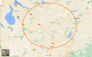
The Cappadocia region is the name of a region located in the Central Anatolian Region of Turkey and has a historical meaning. The name Cappadocia comes from the root of “Katpa Tuka”, which means “Land of Beautiful Horses” in the language of the Persians who lived in this region in the historical process (Article, 2021). Although the boundaries of this region have not been determined precisely and clearly, certain parts of the provinces of Nevşehir, Kırşehir, Niğde, Aksaray and Kayseri are officially accepted as the region (See Figure 1). The Cappadocia region is not officially defined on the political geography map of Turkey. However, this regional area is defined as Cappadocia, both in colloquial language and in international literature.
Figure 1: Cappadocia region geographical area (Source: Google Maps, 2021)
The boundaries of the region were defined in differently at various times. In the historical process, borders were defined in the book “Geography of Anatolia” written by Strabo, who was known as a geographer during the time of King Augustus, one of the Roman Emperors. According to Strabo, Cappadocia was defined as a wide geographical area extending to the Black Sea in the north and the Taurus Mountains in the south, from Malatya in the east to Aksaray in the west.
There is no doubt that today’s Cappadocia have had more specific borders due to the mobility of civilizations in the course of history. Including the provinces of Göreme, Ürgüp, Avanos, Uçhisar, Kaymaklı, Derinkuyu and Ihlara , today’s Cappadocia borders cover an area of approximately 250 square kilometers, that consists of the provinces Nevşehir, Kırşehir, Niğde, Aksaray and Kayseri each having their own unique geographical structures in the appearance of a fairy chimney as well as numerous historical ruins (Cappadocia Web Site, 2021).
However, within this massive geography, the area where Göreme, Avanos, Ürgüp and Uçhisar settlements of the province of Nevşehir are located is described as “Core Cappadocia” (Yıldız and Kılıç, 2016 cited in Türk, 2020, pp. 26-27). This region is the place where touristic activities, fairy chimneys, museums and accommodation places are concentrated (Türk, 2020, p.27). Almost all the tourists coming to Cappadocia visit and stay in these regions.
GEOGRAPHICAL STRUCTURE OF CAPPADOCIA
The Cappadocia region is well known for its world-famous fairy chimneys. Fairy chimneys have become the symbol of the region. Fairy chimneys have been formed by the geographical movements that have taken place in the region for centuries. Hasandağ, Erciyes, and Güllüdağ mountains that are spread around the region were scene to volcanic activity approximately 60 million years ago and erupted lava and tuffs formed layers and stratums in the region. These formed layers and stratums have been eroded by the effects of wind, rain and rivers throughout history and have taken the shapes of what they are today.
Öztürk, Özkan and Şimşek (2019), in their research on the drainage characteristics of Cappadocia, stated that the Kirgibayır topography was formed on the tuffs due to erosional processes in the region and as a result of these, fairy chimneys were formed. Many factors such as topological slope, climatic features, hardness and drainage conditions have affected the development of the fairy chimney topography (Öztürk et al., 2019, p.1).

Post a Comment
You must be logged in to post a comment.